Monte Sano Wisdom Falls
Katie Notbohm, Fall 2024
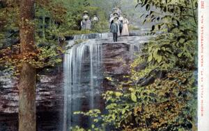
Monte Sano State Park is home to many natural landscapes and views, including waterfalls. Over time, however, the area has changed. According to the State Park staff, due to the development of Big Spring Park, some of the area’s waterfalls dried out slightly or completely. This essay looks at the changes between the area in the mid-20th century, and today, 2024. Wisdom Falls has changed slightly since the postcard was taken and Wisdom Falls is one of the waterfalls left in the area. The area has also changed with new developments and the tearing down of some structures.
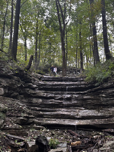
To get to Wisdom Falls, JStor and the UAH Archives have a geolocation, and Google Maps directed the coordinates to be at a trail head. Following that, the waterfall is located on the South Plateau loop and down the trail. There’s a slope and trail to get down to the carved-out rock, or the sound of the waterfall also serves as a guide to the location. The path is tedious, but there is the reward of a rocky area to sit at and take in the surroundings.
When at the state park, there is a little building with replicas, photos, including a copy of the postcard, and information about the area and the Monte Sano Hotel. In the building, the CCC or Civilian Conservation Corps, there was a binder with papers containing information about the State Park, its history, and how it was formed. The area has a lot of limestone and is a part of the Appalachian Plateau and the Tennessee River Valley, with lots of hills and flat, rolling plains (LaMoreaux, 1975). Before the Appalachian Mountains formed, the area was 2,000 feet below sea level and covered in ocean water. Lime, mud, silt, and other sediments formed the rocks and eventually Appalachian Mountains/region that Huntsville is a part of. According to a page in a CCC binder, “Monte Sano State Park-Geological”, the area was “covered by a shallow sea. Trilobites and other fossils have been found on Monte Sano” (Barr, 2007). When there was an upheaval of the crust, the sedimentary beds created the “primeval Appalachian Mountains” (Barr, 2007) and erosion created the mountains to be what they are today.
The area’s name comes from a Legend, found in “The Legend of Monte Sano” and the “Official Program of the Monte Sano State Park Celebration.” The name is said to have originated when a white man and the chief's daughter were sitting on the overlook, and the man asked for her hand in marriage. She accepted, but unbeknownst to them, a member of the tribe who also had feelings for the chief’s daughter was watching and listening to the interaction. The Brave did not want her to accept, whispering, ‘Monte say no, Monte say no”, contributing to the origin of the name (Jones, 1992 and Official Program, 1938). The Alabama State Parks website cites the name, Monte Sano, to be Spanish for “Mountain of Health”.
As Monte Sano was developed, Hotel Monte Sano was built to accommodate those traveling to Monte Sano. Previously, Monte Sano was developed as a place wealthy citizens would go to escape the heat, and others would seek recovery and health from a sickness, like the Spanish Flu (Hill, 2009). The beautiful environment was admired, and many people came in, contributing to the growth of the area. Those who visited Monte Sano at the hotel went to Wisdom Falls, which was close to the Hotel. The hotel opened in 1887 and closed in 1900. The hotel’s remnants are now located on Old Chimney Road (Hill, 2009) and according to the staff in CCC and Hill, the Hotel was not burned down but was taken down piece by piece by a man from Georgia to use for housing and other construction in 1944. So, there is now only a chimney left of the hotel, hence named Old Chimney Road. According to Hill, the hotel was a fine example of Queen Anne Architecture and had lots of beautiful views, natural lighting, and water from the Big Spring Park. The hotel opened in 1887 (Hill, 2009), with plenty of recreational activities and entertainment for the guests, such as buggy rides around the mountain, boardwalks, horseback riding, bowling, and lawn games.
From 1935-38, the State Park was developed (Hill, 2009) along with the Tennessee Valley Association (TVA) and Civilian Conservation Corps (Official Program, 1938). Lots of roads, cabins, camping, trails, and more on the way were developed to make the State Park accessible to the general population, and fun recreationally (Official Program, 1938).
In the later decades of the 20th century, there were changes in population growth. According to Hill, there was a time when the economy, population, and development on the mountain shrunk. But following World War II and the Cold War, the area began to see significant scientific, population, and urban growth, especially with the reinstatement of the Redstone Arsenal. The mountain and State Park helped with the growth and development of the Huntsville area and led it to where it is today.

